|
|
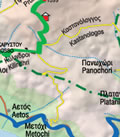
Walk Nikasi - Kalyvia
1,5 hours. Shade at VARDIANI and on the next KALDERIMI
|
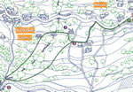 The walk begins in NIKASI village at the covered bus stop. Walk towards KALYVIA. Take the second road to the left, then first right up past the chapel of AGIA IRINI (St. Irene)on your left. Follow the road straight on, where the road bends left. Take the KALDERIMI (stone path) straight ahead. From the path you have a panoramic view of the area. The path goes downhill until it meets a tarmac road. The path is steep and uneven. On your right under a new bridge is an old stone bridge. Straight across the road a path leads to where the streams from LALA and AGIA TRIADA The walk begins in NIKASI village at the covered bus stop. Walk towards KALYVIA. Take the second road to the left, then first right up past the chapel of AGIA IRINI (St. Irene)on your left. Follow the road straight on, where the road bends left. Take the KALDERIMI (stone path) straight ahead. From the path you have a panoramic view of the area. The path goes downhill until it meets a tarmac road. The path is steep and uneven. On your right under a new bridge is an old stone bridge. Straight across the road a path leads to where the streams from LALA and AGIA TRIADA 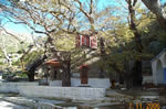 meet. This was the site of VARDIANI (Vardeearnee) BRIGDE which was the west entrance to Karystos City and was guarded. Back on the tarmac road turn left uphill and then take the first KALDERIMI on the right. This KALDERIMI heads uphill, it is steep and uneven. At the top turn right. Follow the path along and past an old house turn right. This KALDERIMI leads to an old stone bridge on the right of a new bridge. Follow the road uphill to AGIOS IONNIS (St. John) in KALYVIA, on your left. Turn right and then left and follow the road back to NIKASI. meet. This was the site of VARDIANI (Vardeearnee) BRIGDE which was the west entrance to Karystos City and was guarded. Back on the tarmac road turn left uphill and then take the first KALDERIMI on the right. This KALDERIMI heads uphill, it is steep and uneven. At the top turn right. Follow the path along and past an old house turn right. This KALDERIMI leads to an old stone bridge on the right of a new bridge. Follow the road uphill to AGIOS IONNIS (St. John) in KALYVIA, on your left. Turn right and then left and follow the road back to NIKASI.
|
|
|
|